Tuesday, January 31, 2017

Logging Adventures By J. N. Dean


Mr. J. N. Dean was a wonderful historian and history writer.  I love his wonderful history stories and stories about the colorful and fascinating Dean family.  Here is one of his stories about Matt Dean and a logging adventure in the Piney Creek near Deanwood.

Many times in rafting did Uncle Matt or his helpers stumble off into cold, deep water, and have to swim out or be rescued by others.

Logs to be rafted were floated down small creeks into Piney, Tradewater River and on into the Ohio, thence down to Golconda Metropolis or Paducah.

Jim Ellis was a dealer in all kinds of timber, and bought on all these streams.

The logs were usually collected in backwater, along-side-by-side, a whallen (a small tree split open) laid across each side of the raft and fastened by wooden pins to each side of the raft, and fastened by wooden pins to each log. 

There were often 50 or more logs in a raft.  It required two or more men to float the raft down stream.

Spike poles (a 12 foot pole with a spike and hook combined and fixed at the end) was used to pull or push the raft from trees and other obstructions along the stream.  The speed was slow in backwater, but in head water, though faster, it was more difficult and dangerous.

Mr. Ellis devised a two-wheeled log wagon.  These wheels were about 12 feet in diameter, and the logs were swung under the axle, and the front ends lifted by a device that secured them.  With three or four yoke of oxen he could haul-in the largest logs, some of them six feet in diameter. 

When this monster of a wagon went from Weston over the old Flynn Ferry road, it created more excitement among the country people than a circus.


An old photo of one of Crittenden County's giant trees being hauled on a wagon and pulled by many oxen.

Wednesday, January 25, 2017

Montezuma Bridge Over Tradewater


The old one lane Montezuma bridge that connected Crittenden County to Webster County on  Hwy. 120 was quite a structure when it was completed in the mid 1920's.


At that time, people in that eastern end of Crittenden County traveled to Providence probably more often than they did to Marion.  A bridge to replace the old ferry was really looked forward to by the surrounding area.
Here is  photo of a group of local men that help construct the bridge. 

In 1977 this old iron one-lane structure was torn down and a new modern three-span concrete structure 34 feet wide by 220 feet long was built.  

 It would be constructed at the same location, but the roadbed was to be raised high enough to put the bridge above normal flooding of the Tradewater River. 

Tuesday, January 17, 2017

Early Days of Marion


The town had been established only for the purpose of a County-seat or as a centralized location for the erection of public buildings to house the government and public records of the new Crittenden County (1842).

Its subsequent rapid growth into a mercantile and residential community was not planned nor even visualized by most of the early Town Fathers, many of whom were also early County Officials.

                                          A group of men bound for county county day.

It has been noted that at first the county Officials did not reside in or near Marion, but would commute to and from their homes on horseback when court was in session.

As it would be most logical to expect, Harvey W. Bigham, the first Crittenden County Court Clerk, must have soon found the rapidly increasing records of the County becoming too bulky for daily carriage in his saddlebags, which had previously been his practice.  He was determined to build a permanent residence in Marion on land which he had purchased from Dr. John S. Guilliam.


At the time there were a few log and frame cabins scattered through which is now downtown Marion and along the Fords Ferry Road (now North Main Street) and the Centerville (now Moore Avenue) Roads within one-half mile of the public square.

Despite the rather persistent rumor that the town was called Oxford before its incorporation as "Marion"  (effect of Feb. 22, 1844), it was always referred to in official records by its proper name.

 The rumor was based on the fact that early mail from Marion was postmarked "Oxford" but this was because that since the new town was not on a main mail stage road until after its incorporation, its mail was carried eastward to be mailed from the post office at Oxford Academy on the Flynns Ferry Road.

Thursday, January 12, 2017

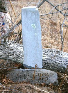
Sugar Grove Area Filled With Nature's Beauty and History


All sections of our county have many aspects of historical interest and beautiful scenery.   Many are hidden from view as they are not located on the main highways.  That makes them all the more beautiful if you have to walk to find them.  It's always good to have a person that lives in the area and knows the spots to visit and also the local history on them.

Some history located on the Sugar Grove Church Road about six miles from Marion off of Hwy. 120.  

The first Sugar Grove church was build in a narrow thickly wooded valley near a beautiful spring, which flowed from the hillside among countless Maple Sugar trees, from which the church took its name.

The windows were made seven or eight feet from the ground and formerly had heavy wooden shutters for protection from Indians.  The church was build on a small incline that looked over the meadow and creek.

In 1884 the church members, with the help of the community built a new frame church about three fourths of a mile northwest of the old church on high ground, which was more convenient to get to.  Where the present Sugar Grove Church is located.


When the new church was built, the congregation marked the old historic location with a monument and an engraved marker in hopes of preserving the location of the first church.


This area is well blessed with many natural caves and rock overhangs, or shelters as they are called.
Indians and probably the first pioneers found shelter under many of these when they first arrived in this area.


One of these scenic view is located across Sugar Creek not too far from the old church location.  To the local families that lived in the area, this was known as the Ora Murray Cave.

The Indian Fireplace overhang, named by the young boys that loved to roam and explore these exciting natural wonders.

No better way to spend a day than hiking and seeing these wonderful beautiful sights in our county.

Friday, January 6, 2017

Crittenden County Once Filled With Mineral Wealth


This article about our fluorspar history was written in 1909.

The area designated as the Mexico-Claylick District embraces three general fault zones extending between Mexico, Claylick Creek and View.  It was practically confined to southern Crittenden County in the area between Claylick and Livingston Creeks.  

 Pictured above is the flourspar storage and loading yard, which was located on the Illinois Central Railroad at Mexico.  Here, loads of spar from the different mines were brought and unloaded, waiting shipment by rail to the Marion Depot to be processed and shipped to other states

The points of shipping were Mexico, located seven and a half miles south of Marion, and Crayne, four and a half miles south of Marion on the Illinois Central Railroad.  

The chief development was the fault system extending from Mexico to Frances, known as the "Tabb" faults.  

The Pygmy Mine included two shafts that ran along a course of a mile south of Mexico and on both sides of the Illinois Central Railroad tracks.

The Haffaw mine, was situated one-half mile west of the Pygmy mine.  The course between the Haffaw main shaft and the Pygmy making the general trend of the Tabb fault zone in this vicinity.  The Haffaw was one of the best developed mines of the entire field.

 
Calcite was prominent in parts of the vein, frequently spotted through the main vein filling of fluorspar.  The vein carried both lead and zinc values.

Keystone Fluorspar Co., had a main shaft one-half mile west by south of the Haffaw mine, still on the Tabb fault system.

The Tabb Mine was  one of the earliest mines of the field, being first opened in the late 1800's and production was continuous into the 1900s.  Numerous shafts and pits were in evidence.

Asbridge Mine was situated on the Tabb system, west of the Tabor mine, and was about two and a half miles from Mexico. 

The Pogue Mine was located close to the west of the Asbridge mine and was also on the Tabb system.